Saturday, November 26, 2011

Day 19 - Nov 26 - At Sea, Bound for Ushuaia, Argentina - Heading back home!

"In memories we were rich. We had pierced the veneer of outside things. We had suffered, starved and triumphed, groveled yet grasped at glory, grown bigger in the bigness of the whole. We had seen God in his splendor, heard the text that nature renders. We had reached the naked soul of man..." -Sir Ernest Shackleton 

The Atlantic Ocean is the second-largest ocean, covering approximately one-fifth of the Earth's surface. The ocean's name, derived from Greek mythology, means the "Sea of Atlas." The oldest known mention of this name is contained in The Histories of Herodotus around 450 BC. This ocean occupies an elongated, S-shaped basin extending in a north-south direction and is divided into the North Atlantic and South Atlantic by Equatorial Counter Currents at about 8° North latitude. Bounded by the Americas on the west and Europe and Africa on the east, the Atlantic is a component of the all-encompassing World Ocean, linked to the Pacific Ocean by the Arctic Ocean on the north and the Drake Passage on the south. A man-made connection between the Atlantic and Pacific is provided by the Panama Canal. On the east, the dividing line between the Atlantic and the Indian Ocean is the 20° East meridian, running south from Cape Agulhas to Antarctica. The Atlantic is separated from the Arctic by a line from Greenland to northwestern Iceland and then from northeastern Iceland to the southernmost tip of Spitsbergen and then to North Cape in northern Norway. While some authorities show the Atlantic Ocean extending south to Antarctica, others show it as bounded to the south by the Southern Ocean.


The Drake Passage was kind to us. Not the same seas as we had experienced on our way into Antarctica. The Seas were pretty calm except for a few rouge swells for a couple of hours! Another day and we reach Ushuaia tomorrow and will be spending a day in Ushuaia visiting the local maritime museum and do a little bit of shopping before heading to Airport to catch my flight to Washington DC. 
What an incredible journey it has been for me, the memories will last a lifetime. I hope this blog of mine has opened your imagination of the miracle continent and that you will plan a trip to this magical place. Adios my friends! 

Friday, November 25, 2011

Day 18 - Nov 25 - Port Lockroy and Fast Ice Landing!

"Strange. There is always sadness on departure. It is as if one cannot after all bear to leave this bleak waste of ice, glaciers, cold and toil... " - Fridtjof Nansen, 1912


This morning we visited Port Lockroy, used as an anchorage by whalers and established as Base A by the British in 1944, as part of a secret wartime initiative to monitor German shipping movements. This expedition was code-named Operation Tabarin, after a well-known Paris nightclub, because team members would be staying there during the darkness of the Antarctic winter. After World War II the station continued in a civilian capacity until 1964, when it ceased operations. This historic base was recently restored, and is now open to visitors as a museum. They have souvenirs for sale (information packs, hats, pins, patches, t-shirts and first day covers), as well as a post office. 

Jougla Point, Port Lockroy - A pretty big colony of Gentoo penguins and Blue Eyed Shags! Check out their blue eyes! 


In the afternoon we found some fast ice to walk on. The ship cuts through an ice sheet that is stable for us to walk on. We then just walk out of the ship onto the ice! It was a fun last day in Antarctica. 


We set sail to Ushuaia, Argentina around 4pm. Good bye Antarctica….until next time! Yes there will be a next time! 

Thursday, November 24, 2011

Day 17 - Nov 24 - Dorian Bay and Palmer Station, Antarctica

"Tell me, what is it you plan to do with your one wild and precious life?" - Mary Oliver 


Dorian Bay is a cove on the NW side of Wiencke Island, located 0.5 mile E-NE of Damoy Point, in the Palmer Archipelago. Damoy Point is the N entrance point to Port Lockroy harbor, on the W side of Wiencke Island in the Palmer Archipelago. The point was discovered and named by Charcot's French Antarctic expedition (1903-05). From inner Dorian Bay, the land rises gently from a bare, rocky landing to two huts, one a well- maintained and stocked British refuge hut, the second a small Argentinian hut. We spotted an incredible sight of Orcas attacking a Leopard Seal while on Zodiacs! This is absolutely a rare scene to witness.


This afternoon we had the rare opportunity to visit Palmer Station, the U.S. research station located in Arthur Harbour on Anvers Island. The U.S. Antarctic Program (USAP) maintains three year-round stations in the Antarctic, the largest in being on Ross Island in McMurdo Sound, at the Geographic South Pole, and Palmer on the Antarctic Peninsula. Palmer fields some 175 projects during this austral summer and we were given an overview of some of these, as well as a tour of the laboratories and living areas. 
Palmer Station, Antarctica

In the afternoon we were supposed to head to Torgersen Island but had to cancel the plans because of ice build up in the area which prevented us from using the zodiacs. 
Tomorrow is our final day on the Continent. We are going to visit Port Lockroy and head back towards Argentina in the afternoon and then 2 days and three nights on seas….the dreaded Drake's Passage. Has been an amazing experience so far. 

Wednesday, November 23, 2011

Day 16 - Nov 23 - Neko Harbour & Paradise Bay, Antarctica

"They are extraordinarily like children, these little people of the Antarctic world, either like children, or like old men, full of their own importance and late for dinner, in their black tailcoats and white shirt fronts — and rather portly withal." - Apsley Cherry-Garrard. The Worst Tourney in the World
<br/>
The Gerlache Strait is named for Adrien de Gerlache, who led the Belgian Antarctic Expedition of 1897-99 on board the vessel Belgica. This expedition charted much of the Antarctic Peninsula region, and ultimately was beset in the pack ice near Peter I Island, becoming the first exploring vessel to ever over- winter in the Antarctic and south of the Antarctic Circle. Gerlache was joined by an international roster of notable polar personalities - his chief officer was a Norwegian named Roald Amundsen, making his first trip to the Antarctic; the ship's doctor was an American explorer and con-man named Frederic Cook, and the geologist and meteorologist of the expedition was a Polish scientist named Henryk Arctowski. 
Neko Harbour, our landing spot this morning, was named after the whale factory ship Neko which operated along the Antarctic Peninsula in 1911-12 and again in 1923-24. An unmanned Argentine refuge marks the landing spot which is surrounded by Gentoo Penguins, Skuas, Snowy Sheathbills and Kelp Gulls. There was a great walk to a viewpoint above the landing beach, and a glacier near the landing site. 


After departing Neko Harbour, we sailed a little ways and entered into a very scenic region known as Paradise Bay. This bay is aptly named because the surrounding mountains look as though they rise straight up to heaven. The Argentine scientific base, Almirante Brown Base is located on the banks of Paradise Bay, as is the Chilean scientific base, Gonzalez Videla. It has several colonies of penguins scattered on the surrounding slopes, as well as a colony of blue-eyed shags. Seals regularly haul out on the ice here. 
The most exciting thing I did was to Kayak in these waters. Yes, I kayaked in Antarctica! It was short lived because the current pushed and surrounded us with ice and we had to be taken back to shore by a zodiac. It was adventurous and exciting. I didn't take my camera so no pictures but am hoping that someone took my picture on a kayak! 

Tuesday, November 22, 2011

Day 15 - Nov 22 - King George and Halfmoon Islands, Antarctica

"Death lies before us, as we sail for the fountain of youth." - Captain Jack Sparrow
The wee hours of the morning were spent approaching King George Island, in the South Shetlands. William Smith first discovered this archipelago on 19 February 1819. Rich in wildlife, by the following season, dozens of American and British sealing vessels were busily exploiting the large fur seal population that bred here. Within two years the seals had been almost entirely eliminated, although populations have now recovered. 
Fildes Peninsula, King George Island is one of the areas in Antarctica of greatest paleontological interest, owing to the presence of outcrops with fossil remains of a wide range of organisms, including vertebrate and invertebrate ichnites, and abundant flora with impressions of leaves and fronds, trunks, and pollen grains and spores that date from the Late Cretaceous to the Eocene.
There are several research stations here, including Frei (Chile) and Bellingshausen (Russia).
We were able to visit two of the research stations in Fildes Bay - Frei Station (Chile) and Bellingshausen (Russian). It is a busy time of year for the stations as they are in full summer research mode, but arrangements were made to land and and explore the outdoor portions of their facilities.

The Chilean and Russian Antarctic Stations

The Russians built a Church on the Base Station

We visited Half Moon Island in the afternoon. Half Moon is a small Antarctic island lying 1.35 km (0.84 mi) north of Burgas Peninsula, Livingston Island in the Antarctic Peninsula region. Half Moon Island has a sizable rookery of chinstrap penguins as well as nesting Antarctic terns and kelp gulls. This small island offers stunning views of surrounding mountains. A small Argentine Station (Camara Base) is located on the island.
A Chinstrap Penguin Colony
A Chinstrap Penguin

Monday, November 21, 2011

Day 14 - Nov 21 - In Antarctica…..finally! Expedition Day in the Northern Weddell Sea

This morning we entered the Antarctic Peninsula region and headed into the Weddell Sea. After two days at Sea with absolutely no sight of land, seeing some land was a blessing and that too Antarctic Land!
The Weddell Sea is a great ice-filled sea that indents the continent of Antarctica between the Antarctic Peninsula and Cape Norvegia in Queen Maud Land. The sea was discovered in 1823 by James Weddell of the Royal Navy, who named it the George IV Sea. The name was changed to honor Weddell in 1900.
Like the 1901-04 Nordenskjold Expedition aboard the 'Antarctic', we took our expedition through Antarctic Sound to skirt the northern fringe of the Weddell Sea. Antarctic Sound is bordered by the Trinity Peninsula to the west and D'Urville, Joinville, Dundee and Paulet Islands on the east. During much of the year, pack ice makes passing through the Antarctic Sound impossible. The Antarctic had to alter her course to travel east of the islands. She was trapped in the ice for several weeks and eventually sank 40km east of Paulet. Captain Larsen and members of his party sledded for 14 days to reach Paulet where they constructed a stone hut in which they spent the winter of 1903. 
Brown Bluff, a continental landing, is a tuya located at the northern tip of the Antarctic Peninsula. It formed in the past 1 million years, which erupted subglacially within an englacial lake. The volcano's original diameter is thought to have been about 12-15 kilometers, and probably formed by a single vent. Brown Bluff is subdivided into four stages: pillow volcano, tuff cone, slope failure, and hyaloclastite delta and into five structural units. The volcano is named "Brown Bluff" because of its steep slopes and its brown-to-black hyaloclastite. 


I set foot officially on Antarctic Land this morning at 9:18am (Local Time) on Brown Bluff. What a feeling. This is the coldest, driest, loneliest place on earth. The temperature this morning was frigid at -6 C or with a windchill it was 15F I think. We were instructed to layer up as much as possible. I wore two pairs of gloves and that didn't help for long! But I ended up spending 2 hours on Brown Bluff which had a huge Adelie Penguin Colony. These penguins are little and cute! 
An Adelie Penguin


We hoped to encounter our first sea ice of the voyage today but we didn't find anything that was good enough to walk on. A little disappointed but hoping we find some during our stay in the Antarctic.
Looking for fast ice for us to walk on!
The ship tearing through ice - picture taken from the top of the bow of the ship.
Ship 'Kissing' and Iceberg!

Sunday, November 20, 2011

Day 13 - Nov 20 - At Sea….really rough Seas!

I lay there, all the day long, quite coolly and contentedly; With no sense of weariness, with no desire to get up, or get better, or take the air; With no curiosity, or care, or regret, of any sort or degree, Saving that I can think I can remember, in this universal indifference, Having a kind of lazy joy - of fiendish delight, if anything so lethargic can be Dignified with the title - in the fact of my wife being too ill to talk to me. -Charles Dickens on seasickness
OK the seas have been pounding the Ship since yesterday afternoon. 20-30 footers! I have been very drowsy and a little bit uneasy but nothing major. Well its the first time on a Ship for me!
About the seas I am on right now as we sail towards the Antarctic: 
The ocean area from 40° south latitude to near the Antarctic Circle has the strongest sustained westerly winds found anywhere on earth. The highest frequency of gales is reported between Longitude 20° and 60°E, north of the Ross and Weddell Seas and the approaches to the Drake Passage. Interaction between the frigid air coming off Antarctica and the relatively warm and moist air from the lower latitude ocean areas creates the cyclonic "Roaring Forties", "Furious Fifties" and "Screaming Sixties" storms. They make the region from 40° to 60°S one of the stormiest areas in the world. The main course of these cyclones is from west to east around the periphery of Antarctica. 
Westerly winds and the associated Antarctic circumpolar current cause massive amounts of water to move constantly from west to east all around Sub-Antarctica. It has been estimated that on average some 145 million cubic meters of water per second (38 billion gallons per second) are constantly on the move in this way. This flow rate is 150 times all the rivers in the world combined. 
Now say Wow to these pictures! It has been this way since yesterday afternoon after all these are the craziest seas in the world! Picture taken from the Bridge which is at least 40 feet high!


Tomorrow is going to be an exciting day…..since we are going to set foot in Antarctica. Woohoo!

Saturday, November 19, 2011

Day 12 - Nov 19 - At Sea....sailing to Antarctica!

Nothing to write today. Spent the day relaxing after a hectic time in South Georgia! All the hiking and landings have proven to be more tiring than anticipated. It has truly been an expedition and not to be mistaken for a cruise!
See you all tomorrow!

Friday, November 18, 2011

Day 11 - Nov 18 - Gold Harbour, South Georgia and then set sail to Antarctica!

Southwards, a magnificent Alpine country, illumined by the rising sun, rose slowly from the sea; there were mighty fells with snowy crowns and with sharp, uncovered teeth, around the valleys through which enormous, broad rivers of ice came flowing to the sea. - J. Gunnar Andersson,1902, Describing South Georgia
Today was the final day in South Georgia before we began our long two day and three night sail to Antarctica. We are expecting some rough seas just don't know how bad they will be. Somewhere between 20 and 30 foot swells can be expected…usually and then there are the worst 60 foot swells!
Before we set sail for Antarctica we made a final trip to Gold Harbour once again this morning. Had a chance to see the King Penguins colony once again.
The magnificent Gold Harbour

Two "teenage" elephant seals fighting…….practicing! Even though they are not anywhere close to the adults fighting, injuries do occur.

At 1pm local we set sail to Antarctica. Can't wait to set foot on the miracle continent. Before that I do have to see how I take to the rough seas….will keep you posted.

Thursday, November 17, 2011

Day 10 - Nov 17 - Hercules Bay and St. Andrews Bay - South Georgia

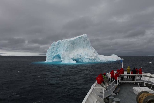
"King Weather is the tyrant of these latitudes, and he rules South Georgia with ruthless despotism." - Frank Hurley, Shackelton's Argonauts
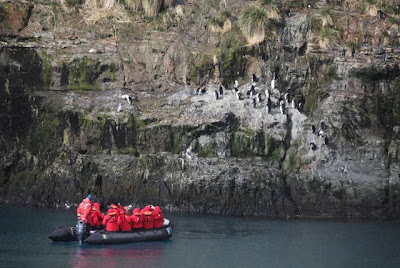
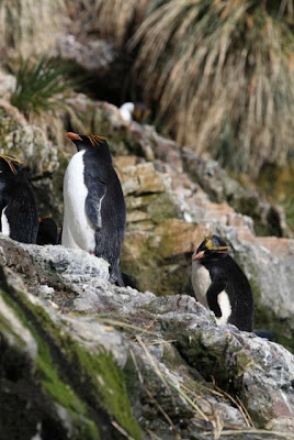
This morning we sailed a short distance to a beautiful little fjord called Hercules Bay. This protected bay is a good place to see the dynamic little Macaroni penguins as they come and go to a colony on the tussock-covered slope above the rocky shoreline. We also observed many other species of birds which breed and/ or frequent the area including the light-mantled sooty albatrosses flying overhead, as well as elephant seals and fur seals.
There were no good landings here, so we cruised in Zodiacs in order to get close to the wildlife. The name "macaroni" derives from the eighteenth century dandies who made the Grand Tour to Italy and affected continental tastes and fashions, dyeing their hair in streaks and extending crests over their ears. Arriving back in England they were promptly called "macaronis" by the yokels, whose only association with Italy was the pasts with which they were familiar. Hence, on the American side of the pond, "Yankee doodle went to town, riding on a pony, stuck a feather in his hat and called it macaroni." On exploring Antarctica, both British and U.S. sailors, meeting the gaudily crested penguins, promptly christened them after their style.
Cruising Hercules Bay looking at the Macaroni Penguins.
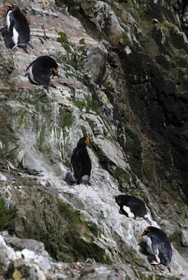
Macaroni Penguins on the rocky slopes. Its amazing how they climb such steep slopes and that too slippery!
A Macaroni Penguin up-close
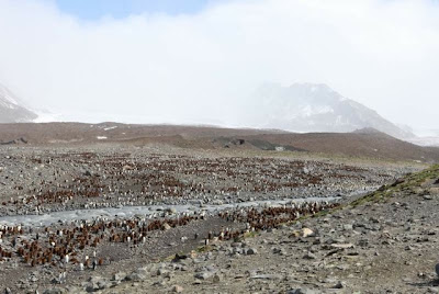
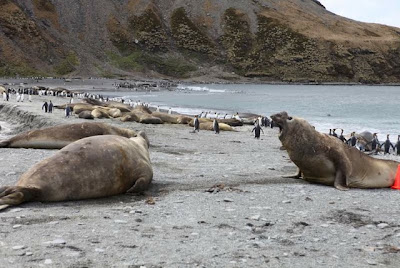
In the afternoon we sailed to St. Andrews Bay. It is the home to the largest King Penguin colony on South Georgia, numbering over 100,000 pairs. Not only does the penguin colony span the length of the glacial river, elephant seal haul outs seem to stretch on for miles ashore, making it look like a very lumpy beach indeed. They say "there are no boulders on the beach….there are only animals!"
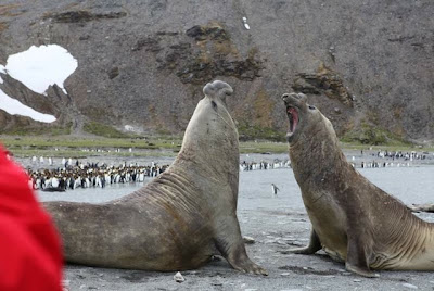
Elephant Seals - the males have that snout nose and are ten time bigger than the females! One thing is that you never walk in between two male elephant seals. If they get into a fight anything and everything will be pummeled through. They are not trying to attack you rather trying to get to the other male Elephant seal who is most probably trying to steal the female! And did I mention, the males weigh about 3000 Pounds!
Elephant Seals carpeting St. Andrews Bay
Two male Elephant Seals in a fight
The largest King Penguin Colony in South Georgia!
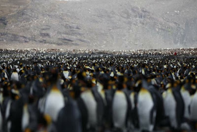
This is just one frame of the total 14 frames I had to take to fit the entire colony…and by the way I use a Full Frame Camera! It was an estimate that there were at least 250,000 pairs in the colony at that time!

Wednesday, November 16, 2011

Day 9 - Nov 16 - Fortuna Bay, Stromness Harbour and Grytviken, South Georgia

I go exploring because I like it and it's my job. — Sir Ernest Shackleton
This morning we anchored in Fortuna Bay. We recreated the last leg of Shackleton's epic crossing of South Georgia, before continuing to Stromness. This hike is 4 miles long with 1000 feet of elevation gain. It was over a variety of surfaces - tussock grass, gravel, boulders, glacial plain with streams, and snow of varying depths. This is a one way hike from Fortuna Bay to Stromness.
It was an incredible feeling to have done the hike. At places it seemed a little challenging because of the steepness of the slope and the loose gravel but we all made it. The Ship dropped us at Fortuna Bay and came on the other side of the mountains to pick us up at Stromness Bay.
On The Hike - Recreating Shackleton's final leg!
Stromness, site of our morning landing, is a former whaling vessel repair station, named after the three-mile wide body of water that must be passed through to reach the station. It is here that Shackleton arrived after a 36 hour hike across South Georgia to reach help and save his men on Elephant Island. Although we are not permitted to approach the station buildings closer than 200m, the beaches and plains of the bay are rich in wildlife, including elephant & fur seals, reindeer, king & Gentoo penguins.
Remnants of Whaling Station at Stromness.
This afternoon, we landed at the former whaling station of Grytviken, established in 1904, by the Norwegian Sea Captain Carl Anton Larsen. The station changed hands a number of times and was finally closed in 1965. The small cemetery just outside of town is the final resting place of Sir Ernest Shackleton, and we paid our respects to "the Boss" with a toast at the grave, after visiting the station and museum.
The Whaling Station at Grytviken
At the cemetery of Shackleton
With the "Boss" - RIP!

Tuesday, November 15, 2011

Day 8 - Nov 15 - Gold Harbour and Ocean Harbour, South Georgia

This morning we visited Gold harbor, near the southern end of South Georgia and Ocean Harbour on the north coast of South Georgia. Gold Harbour is backed by an amphitheatre of hanging glaciers and cliffs at the base of the Salvesen Range. The rapidly retreating Bertrab Glacier has left a series of lagoons, the largest of which is lined by a wave-swept moraine which marks its recent extent The northern entrance to the bay is protected by Gold Head and a series of Huffs and cliffs which jut out to the east Nestling between the bluffs of Gold Head and a steep-sided lateral moraine to the south, lies a tussac-covered glacial outwash plain riddled with small streams and pools, it is the site of a large king penguin colony.
One of the largest King Penguin Colonies
An Elephant Seal on the beach.
Penguin chicks at the colony
An elephant Seal pup. Very friendly and curious. Mothers feed them for 3-4 weeks after birth and leave them on the beach to figure out life on their own. They are called "wieners" or "sausages" since they are plump and look like sausages. They have to figure out everything from heading to the waters, to hunt for squid!
Video chronicler Josh with a seal pup
Ocean Harbour is a deeply indented bay on the north coast of South Georgia. It was an active whaling station between 1909-1920, and old sealing trypots can still be seen here. There is also the wreck of the Bayard here, a 1300 tonne, 67 m (220 ft) long, iron hulled boat built in 1864. Moored at the cooling station at 1911, a gale blew her loose across the bay, where she lies now. Ocean Harbour has a small cemetery with eight graves including the oldest known grave on the island - that of Frank Cabrial (1820) of the sealer Francis Allen. The first Reindeer to South Georgia were also introduced here by Norwegian whaling entrepreneur Carl Anton Larsen and his brother in November 1911.
Bayard
Remnants of a Whaling Station at Ocean Harbour